INTER LINKING OF RIVERS OF INDIA
(INCLUDING THE SARASWATI RIVER COMPONENT)
METHODOLOGY AND IMPLEMENTATION
VIWED IN
A WIDER PERSPECTIVE
FORWARDED TO
GOVT. OF INDIA AND ALL STATE GOVERNMENTS
JUNE : 2005
BY
JAGDISH GANDHI
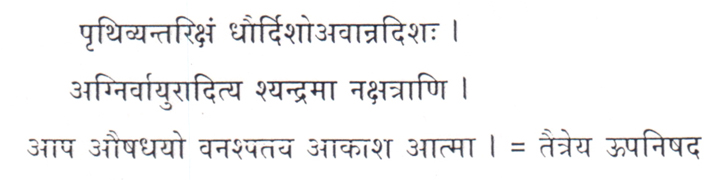
(Earth, space, fire, air, sun, moon, water, life – sustaining plant kingdom, and vegetation are natural elements central to evolution of cosmic life and biosphere)
Traitreya Upnishad
India is endowed with the largest water bearing cloud system in the word. In July-August, the cloud spread over the land mass of India covers more than a million square Kms in a single sweep, roughly the size of Western Europe. Fed by tropical rains and the melting Himalayan snow, as the case may be, the river of India, both Himalayan and peninsular, carry an enormous discharge of an estimated 16,00,000 million cubic mts of water per annum. The glacial rivers, perennial by virtue of their Himalayan origin, are the life lines drawn on the fertile plains of North India. Of the many peninsular rivers criss-crossing the country south of the Vidhyas, the Narmada, Tapti, Godavari, Krishna, Kaveri etc. possess immense potential in terms of hydel power, irrigation, inland water-borne transport and navigation, provided the said river systems, alongwith their contributories and distributaries are comprehensively interwoven to facilitate inter basin transfers of excess volumes produced during a generous monsoon. However, does the so called availability of “Excess” or ‘Surplus” water exist in reality or is it only a statistician’s delight? And, if such a projected transfer of water resources can indeed be brought about, then at what cost in terms of money, sweat, toil and tears?
The write-up that follows these lines is an earnest delineation of contours and an analysis of factors that can influence the future profile of India on the water of front.
1.NO INDIAN RIVER OTHER THAN THE BRAMAPUTRA CARRIES ‘SURPLUS’ WATER
The very concept of utilization of what constitutes ‘Surplus Water’ is fundamentally flawed. Which river, primarily of Indian origin, carries surplus water? The Ganga or Yamuna? Or the Narmada, Godavari, Kaveri? Or the Chambal or Sonn or Mahanadi? Neither. The Central – India or Peninsular – India rivers, though not of glacial origin, do have a good annual flow, mostly augmented by the monsoon, even if erratic. These rivers have a lean existence during the summer months and they swell during the monsoon, if the latter is generous. If not, the flow during the subsequent dry season falls to a trickle.
The rivers of Himalayan origin are already showing clear sings of decline, primarily due to the retreat of the glaciers from which they originate, the Ganga and Yamuna included. During my frequent forays into the Himalayas as a trekker, I have noticed the unfailing signs of glacial recession culminating in drop of the volume of snow stockpiled. The situation is compounded by diminishing replenishments in the form of seasonal snow fall.
I am no glaciologist myself, as such I am not equipped with the knowledge of behavioral pattern of the glaciers. Nevertheless, I surely can read nature’s signals which are silent and yet very clear. Therefore, the quintessential question is as to where the surplus water is to come from? Whether there is enough Ganga water at farakka for feeding the Hoogly to keep the Kolkata port afloat? We all know that the Ganga is already slowing down, more so in the segment between Patna and Farakka. If we were to stand on the bridge across the Ganga at Patna and look for the movement of the river under the bridge, we would see India’s prime river standing still, almost. Beyond this point, the progress of the river is agonizingly slow, merely inching its way onward. Here is a photograph down below of a Terai river near Ramnagar in Uttar Pradesh,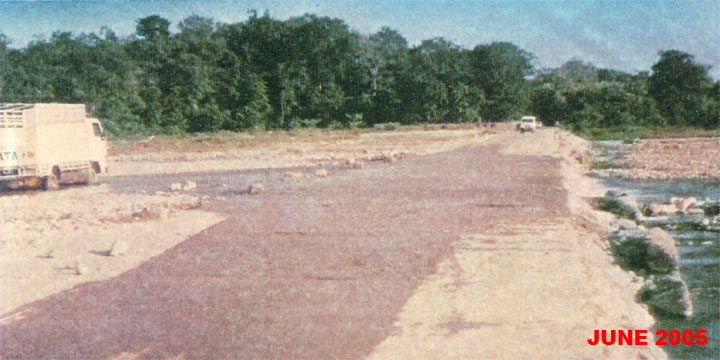
Photograph No.1
which is only a monsoon stream. This photograph represents the status of every river in India, as to how silt-deposits, brought down from the hills, deplete the water holding capacity of river-channels. We can very well see and perceive the level difference between the river bed downstream and upstream. Farakka is comparatively better, only because the river it impounds, the Ganga, happens to be a perennial river, and of glacial origin at that. If even a minimal quantity of water is siphoned off from the mainstream Ganga any further, in course of time the silt-deposits will out-volume the water impounded.
2.THE BRAHMAPUTRA WILL FORM ISLANDS OF ALLUVIA IN THE BAY OF BENGAL IF LARGE VOLUME OF WATER DIVERTED. WILL ALSO BLOCK BOTH CHITTAGONG AND KOLKATA (PORTS)
One of the largest rivers in the world, the Brahmaputra carries enormous volume of water, registering the highest annual discharge of any river of the sub-continent. Being a turbulent river, having catchment areas comprising of endless rows of mountainous terrain, it is known for its devastating floods, shifting channels, erosion of banks and an enormous complement of silt that rolls into the planes downstream. The river is undoubtedly a potential source of water.
It is estimated that the river carries an annual volume of about 330 million cubic meters of silt, enough to create an island-country every fifty years, if the sediments were to be deposited at a single point. As if fully known, the entire arc of islands, dotting the Ganga –Brahmaputra estuary in the Bay of Bengal, is formed by the deposition of silt brought down from the Himalayan heights by the Ganga-Brahmaputra combine along with their tributaries since aeons. Any diversion of water, therefore from the Brahmaputra and even the Ganga, will only aggravate problems, not mitigate any. It will not only block Chittagong in decades to come, it will also adversely affect Kolkata, (even though the said port is not exactly on the Brahmaputra), through the spread and backlash of silt deposition. Though this is not a phenomenon that happens overnight, IT WILL NEVERTHELESS HAPPEN, SURELY AND WITHOUT FAIL, AT NATURE’S BIDDING. In fact, it is already happening to Kolkata on the Hoogly, as the intake into Bhagirathi from Farakka is falling due to large scale silting.
3. WE MUST NOT CONFRONT NATURE; RUN WITH IT, NOT AGAINST.
Whereas most rivers generally tend to flow away from their respective sources of origin, the Ganga, while flowing away from Gangotri, nevertheless keeps flowing almost parallel to the Himalayan mountain chain for over a thousand kms until it turns South in Bengal for onward journey into the Bay. The Ganga, reinforced by the tributaries from beyond its Southern and Northern Bank fronts, creates an elongated bowl sandwiched between the foothills of Himalayas on the North and those of the Vindhyas on its South. The message is clear. That is how the Divine has ordained India’s largest Water Basin to be, the incline of the bowl as a whole leaning eastward. If we try to bring in, from diametrically opposite direction, the mightly Brahmaputra (even a part of it), then we are not only running against the flow direction of the Ganga Basin but also against Nature’s blue print.
4.WE HAVE TWO-FOLD PROBLEM ON HAND. DIMINISHING VOLUME OF WATER, INCREASING VOLUME OF SILT.
We have all along been talking about the falling availability of water and the damage it can cause on the socio – economic front. However, we have all along ignored and failed to address the primal contributing factor responsible for depletion of water resources coupled with inversely proportionate rise in accumulation of silt deposition. The systemic deforestation of the mountains and more so of the Catchment Areas (I would prefer to label phenomena as ‘The Disrobing of Mother Earth’) has deprived the Earth of its protective vegetation cover, vegetation that holds in its fold, through its roots, the fertile upper crust of the earth. Whereas soil and water conservation should be an integral and inalienable part of any development project, it is precisely these two very vital elements of nature (viz. Prithvi Tatva and Jal Tatva) that have all along been meted out an indifferent treatment, with the result that most of our reservoirs constructed during post-independence period have lost their planned and designed holding capacity, thick layers of silt having occupied the depthical space, leaving only shallow depths for water occupation. As is well known, a number of small irrigation-cum-soil conservation dams were constructed (with good intent and rightly so) in the upper reaches of Damodar Valley like the Adivasi Dam, Deochanda Dam, Garia Karma Dam etc. to hold back rain water and to prevent and arrest soil erosion, albeit not with much success. Therefore, this inescapable realization must quickly dawn on us, that no man made mechanism, even if well intended and well-designed, can hold in its fold water and soil as much as, or more than, the thick cover of vegetation, provided by and as exists in, nature. The more we interfere with the varied functions of nature, the greater the calamity we expose ourselves to. Here are two photographs
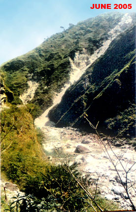
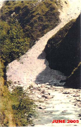 (Photographs no.2,3)
evidencing the abovesaid assertion. These photographs clearly show how soil erosion can almost block the flow of even perennial rivers, which will ultimately sweep the eroded soil into the channels of parent rivers in the plains.
The Ganga is endowed with the largest drainage basin in India. Countless number of streams, small and large, flow down the Himalaya mountain chain and roll into the Ganga, bringing in their wake millions of tones of alluvial deposits. The spread of the sediment is so deep and wide in the principal channel of Ganga that the latter’s progression upto the sea, beyond Patna, has slowed down considerably, jeopardizing inland navigation and more so, the existence of Kolkata Port itself, Farakka reservoir not withstanding. This phenomenon, i.e. large scale siltation of the river bed, has the potential of causing disastrous effect on the socio –economic-politico fabric of the nation if Ganga water is sought to be diverted from its upper reaches, as is probably envisaged in the Inter Linking of Rivers (ILR) Project
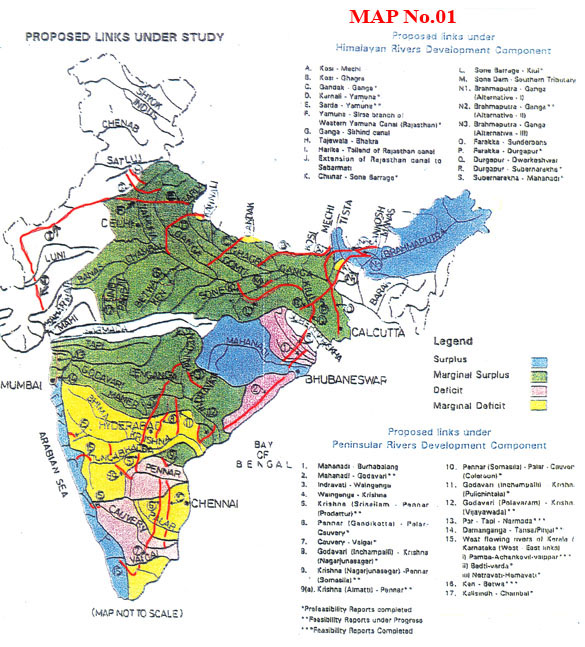 (Map No 1)
Thus, if the siltation problem, arising from illegal mining and deforestation is not addressed in depth and immediately, and if the ILR project is sought to be inaugurated without dealing effectively with the siltation scourge, the entire network of interlinks will be rendered infructuous in course of time.
5.HYDEL/IRRIGATION ENGINEERS CAN ONLY DIVERT RIVER COURSE, THEY CAN NOT CREATE AQUIFERS, THEY CAN CREATE CANALS, NOT E CO-SYSTEM.
Just as the Nature’s blue print delineates the course of rivers on land, it has also established a subterranean labyrinth of aquifers criss crossing the substrata. We know that the aquifers are nature’s water carrying arteries within and under the landmass, and as such, provide infinite sustenance to life that exists hidden from man. In fact, the vegetation on the upper crust of earth draws their sustenance from the aquifers during the dry months. (This also explains the fulsome existence of vegetation in desert tracts even during summers). Just as the rivers have their contributories and distributaries on the land, the aquifers too have their network of water carrying conduits under the mass.
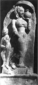
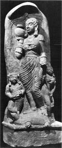
Further, we must realize that while the Ganga is home to the famed Indian Ghariaal (in the upper stretch) and Dolphin (in the downstream stretch) the Yamuna is home to Kachhuwaas (Tortoise). These species have been existing in their respective river stretches since time immemorial. They have been immortalized in the timeless sculptures in the corridor of Ancient India.
(Photographs no4,5)
Photograph of sculptures showing River Goddess Ganga standing on Ghariaal (River Crocodile) and River Goddess Yamuna on Kachhuwa (Tortoise). And during the preceding millennia, these species have not changed their respective address, they have not exchanged their habitats with each other. We will not find the Gharial in Yamuna, nor the Kachhuwa (Tortoise) in the Ganga. So much so that neither the Ghariaals (inhabitants of central and lower course Ganga) both being the inhabitants of the same parent river, have ever exchanged their respective places!
The foregoing sends us an irrevocable message. Neither the aquifers nor the aqua life should ever be interfered with. The rivers, the aquifers, the aqua life, the vegetation, algae and so on, all live an interwoven existence. Together, they make an ecosystem that so far has endured the plunder of man. Therefore, putting the Brahmaputra and sharada in anti-gravity direction across the naturally formed basins in defiance of nature’s norms can only prove to be counter productive fraught with disastrous consequences.
6.DIVERTING THE SHARDA INTO YAMUNA WILL BE AN ENGINEERING WASTE
Are we trying to put the Brahmaputra into Ganga? And Ganga into Yamuna? And Sharda too into Yamuna? If true, as it appears from the ILR Map (Map No.1), it is difficult to understand the rationale. It is an invitation to disaster, besides the whole exercise being an engineering waste. For academic argument sake, even if the Bangla Desh Government happens to clear the partial Brahmaputra diversion through its territory (even as we have failed to persuade our own Punjab State to let the Satlej through its territory into Yamuna in Harayana!) the ground reality is that such a diversion, even if technically feasible is neither needed nor desirable. An inquisitive glace at the ILR Map (Map No.1) will show how the map defies the factors of geography and gravity. For example item (j) in Map No.1 (extension of Rajasthan Canal into Sabarmati) shows that the said canal, beyond Jaisalmer, is working against gravitational force and is also cutting its way across the Relict Valley in a clear defiance of the geophysics of the territory. Instead of using the network of paeleo channels naturally laid in the Relict Valley as natural conduits that can carry Himalaya waters upto Kachh through the arid region of Rajasthan, our planners in all their wisdom have opted to work against nature!
Similarly, putting the Kose into Ganga (B) (Ganga Basin ) and Vainganga into Krishna (4) (Peninsular Component) fail to take into consideration the vital factors of gravity, the geo-physical structure and geographical incline of River Basins as they exist in nature. Similarly from the point of views of geographical uniformity, physical proximity and direction of gravity, it is the Satlej, and not at all Sharda, that should be linked to Yamuna, preferably into the West Bank Yamuna canal (WBYC) rather than into the principal river itself. On neither of these counts, does the Sharda qualify for merger into Yamuna. (and neither would Punjab allow the Satlet - Yamuna link to go through!)
7.DEVELOP AND INTERLINK ONLY PARALLEL RIVER SYSTEMS. TAKE UP ANY ONE AS A CASE STUDY.
No river flows solo, they take their systemic support apparatus along. No river exists all alone without adequate ecological support. All river basins anywhere are an aggregate of elements of geo-physics, flora-fauna, forest canopy, soil and mineral variants, geological structures, watersheds, water bearing cloud chemistry and so on. These elements and the effects thereof, differ from basin to basin. We will surely have a comfortable sailing if we opted to develop parallel rivers flowing through the same and/or similar basins to begin with. Parallel rivers by and large share the same flow direction, the same catchment area in a larger context, the same geophysical support base, the same vegetation cover and are fed by the same water-bearing cloud systems. Any such pair or group of rivers makes them natural sisters co-existing within an equitous eco system. Some examples:
- Narmada – Tapti (Central India)
- Waiganga – Wardha- Penganga – Dodna - Pravara into Godavari (Peninsular)
- (a) Bhima – Varna – Ghat Prabha – Malprabha – Musi into Krishna.
(b) Tungabhadra – Vedavati into Krishna. - Hemavati – Kabini – Amravati into Kaveri.
- The Ganga Basin :
(a) Yamuna – Ganga – Gomti – Tons - Sharda (Ghagra) into mainstream Ganga upstream of Patna.
(b) Banas – Kalisindh – Parabati – Sindh into Chambal into Yamuna into Ganga.
(c) Betwa – Dhasan into Yamuna into Ganga.
(d) Rihand – Kanhar into Sonn into Ganga.
All these (b-c-d) groups of rivers flow into Ganga upstream of Patna from the foregoing, it can be observed that all group 5(a) rivers are of Himalayan origin and are all snow fed and rain – fed rivers as well. The group 5 b-c-d rivers are rain fed rivers endowed with a potent flow, though lean during summer months. Both these zones, North of Ganga and South of Ganga have markedly different evolutionary history and geography, sources of water, watershed, cloud system and chemistry. The prime reason being that the respective mountain chains stand millions of years apart in age, the Himalaya being the younger of the two.
Geologically, the Vidhyas have firmed up. They release comparatively less soil into the rivers than their counterpart up north, the latter being a huge mass of loose soil that gives way readily to any impact, from nature or from man. Himalayan rivers therefore bring in their wake huge quantity of silt that is ultimately deposited in the mainstream Ganga and in the estuary.
8.NO COMPARABLE REGION IN THE WORLD MORE READILY LENDS ITSELF FOR AUTOMATIC REPARIAN ARTERIAL LINKING THAN THE VEDIC SAPTA SINDHU KSHETRA.
The Sapta Shindu Kshetra (SSK) of the Vedic fame comprised of the present day Kashmir, Punjab, Hariyana, Rajasthan, N. Gujarat, Kachh, Saurasthra and the whole of what is Pakistan today as is known to all those with an insight into Vedic India. The said SSK was an extensive landmass watered by seven Himalayan rivers, led by the mighty Sindhu, from which India derives its name. In terms of dependent agriculture and food supply, the Sindhu is easily the most significant river in the world. Taken along with its tributaries, the irrigated area under the Sindhu system is by far the largest in the contemporary world, much as it was in the ancient times.
Post – independence period, India has signed away in favour of Pakistan, to India’s detriment, waters of perennial contributories of the Sindhu system vide the Sindhu water Basin Treaty. However, the waters of the Satlej can still be harnessed and effectively applied to turn the arid zones of Haryana, Rajasthan and Kachh into sheets of green, through a rational, comprehensive and judicious management of the Satlej – Yamuna system bounded by the Indo – Pak border on the west; the Ghagra – Markand – Saraswati drains on North; the Aravalli Range on East and North Gujarat – Kachh combine on South, the landmass of Haryan – Rajasthan is endowed with a natural geographical incline that offers unhindered passage for Himalayan waters to drain into the Great Rann of Kachh by gravity without any mechanical assistance. The entire tract between Jodhpur and Jaisalmer is interspersed with low-rise parallely laid hills so placed as to allow passage of water from NE to SW direction through and between their folds, known as the Relict Valley. Such is the incline thereof that all water, if released from the Shivaliks (and so from the Aravallis ) will automatically drain into the Great Rann of Kachh inconformity with gravity.
9.THE SATLEJ – YAMUNA SYSTEMS STRONG ENOUGH TO FEED HARYANA – RAJASTHAN – KACHH IF LARGER NATIONAL PERSPECTIVE OVERRIDES NARROW POLITICAL INTERPLAY.
The “Indus Basin Water Treaty’ in context of a divided India, leaves us primarily with waters of Satlej river in effect for all practical applications. If we can judiciously plan, implement and manage the waters of Satlej in conjunction with those of Yamuna, the dream of converting the arid zones of Rajasthan and Kachh into granaries can never be too far from realization.
The Yamuna arrives at East of Yamunanagar in Haryana after its descent from the Paonta Doon. The West ank Yamuna Canal (WBYC) takes off from Yamuna at Tajewala and feeds Hissar – Hansi – Bhiwani – Rohtak – Jhajar segment of Haryana
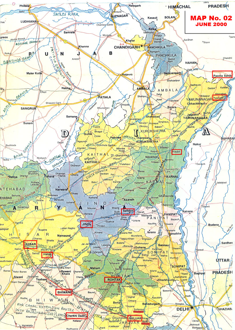 (Map No. 2).
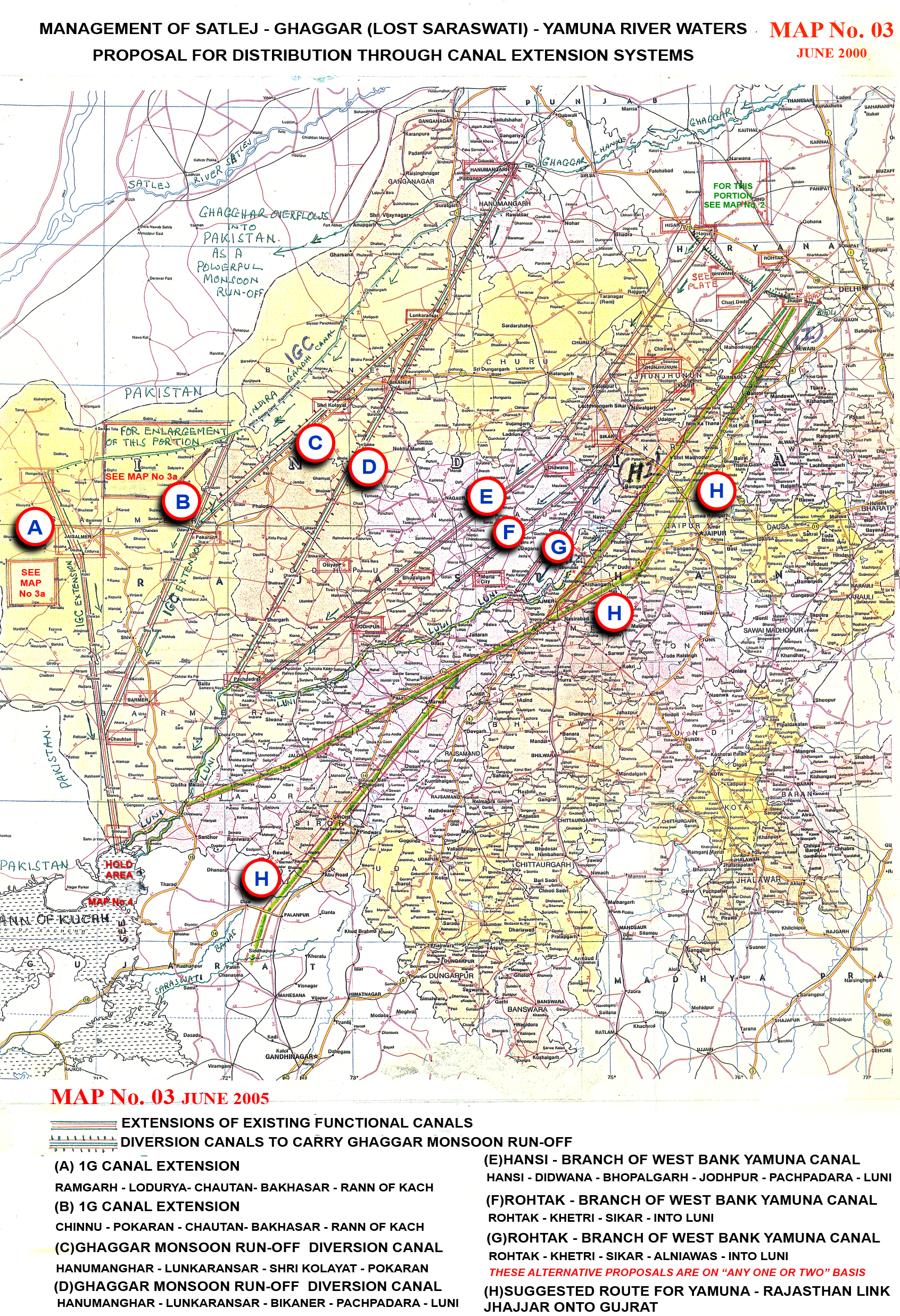
It should suffice to suggest that we have about five discharge points, three at least, from where supplies can be drawn and taken South – West upto Rann of Kachh, through Rajasthan. These points are as follows:
1. Extensions E-F-G-H will carry Yamuna waters from their take off point at various tail ends of existing canalas. (Map Nos.2,3)
 (Map No. 3)
 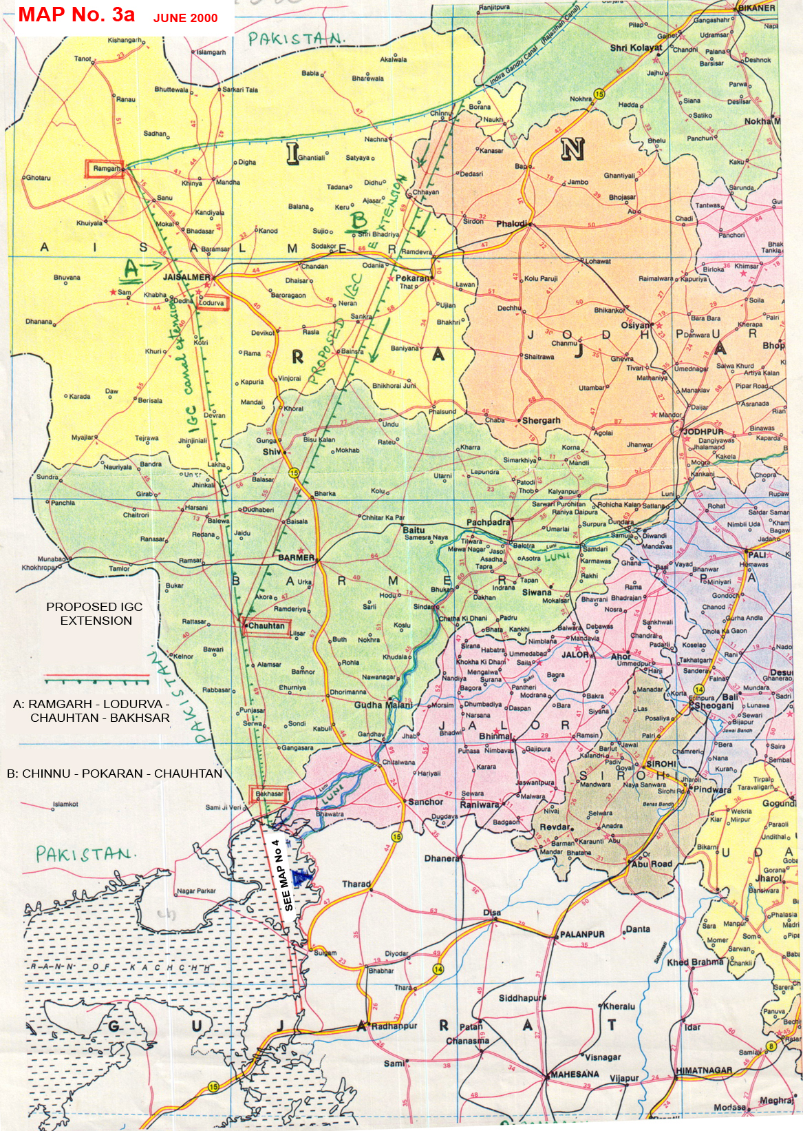 (Map No. 3a)
2. Extension A & B will draw it supplies from Govind Sagar Sarovar on the Satlej at Bhakra – Nangal via India Gandhi Canal (Rajasthan Canal) (Map No2,3).
3. Extension C and D will carry only the monsoon run-off, whenever and whatever, from Shivalik mountains and adjoining areas, the take-off point being Suratgarh – Hanumangarh on the Ghaggar which is only a monsoon run off channel. (Map No. 3.)
4. Of all these sources of water, rivers Satlej and Yamuna being of Clacial Himalayan Origin are perennial rivers. Whereas, the Ghaggar being only a ran-off channel, carries only the monsoon – release from the Shivalik mountain range for only about 20 rainfed days during the monsoon. However, the persistent discharge during the monsoon is recorded anywhere between 10000 cusecs to 70,000 cusecs at Hanumangarh in Rajasthan. This volume of monsoon discharge is allowed to roll into Pakistan
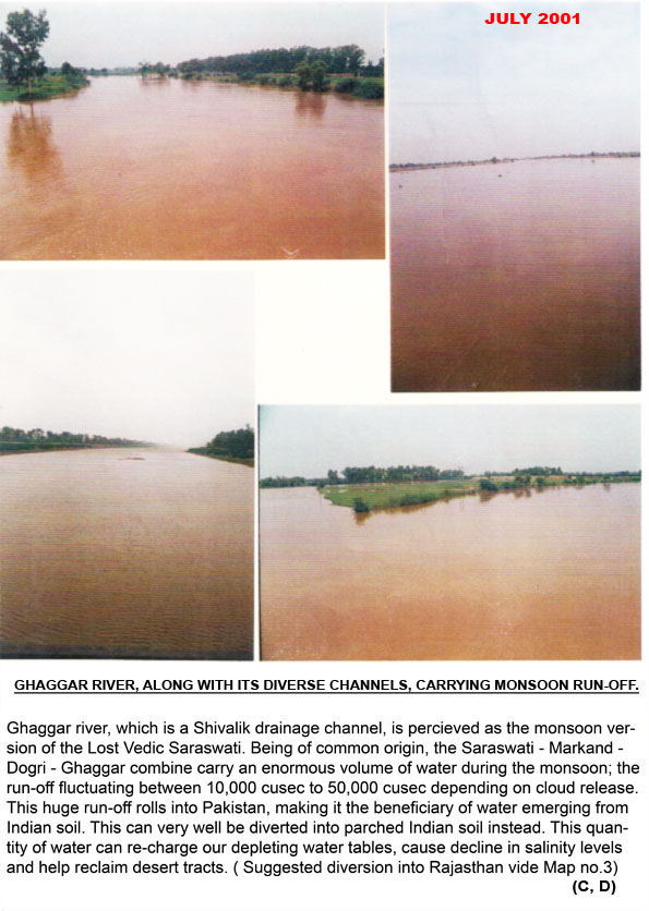 (Photographs No. 6 collectively). The suggested diversion of this quantity into Rann of Kachh through Rajasthan is shown as C and D in Map No. 3.
This monsoon run-off through Ghagger is not subjected to any treaty (eg. Indus Basin Treaty) is also not a matter of dispute between any two or more States of India (eg. Punjab, Haryana, Rajasthan) and therefore can be harnessed for mutual benefit without causing any heartburns.
The various sources of water on the Yamuna to draw from are as under:
- Tajewala Headwaters Barrage on Yamuna.
- The Asan Barrage on Asan River at Paonta sahib on Haryana – Uttaranchal border.
- Dak Pathar Barrage on Yamuna at Dak Pathar in Uttaranchal.
- A massive Dam across Yamuna at Lohara, about 40 kms.
- Upstream from Dak Pathar, which is presently under construction.
The Tons River Headwaters at Dak Pathar. The Tons (Tamsa) is a major tributary Yamuna which runs into Yamuna 2 kms upstream from Dak Pathar and carries larger volume of water than the mainstream Yamuna itself.
Moreover, both the parallel sister streams viz. Yamuna and Tons offer multiple number of sites upstream of Dak Pathar for creating storage facilities. If implemented, there will be no scope left for any quarrel between the downstream States, besides obviating the imaginary necessity of having the Sharada intervention to augment the Yamunas’s volume of flow (item No. E in ILR Map No. 1).
Rising from Rakshat Tal of Manas Sarovar group of lakes, the swift flowing Satlej (Shatadru or Satudri of Vedic literature) contributes a great deal in greening of Punjab and Rajasthan. The Satlej is impounded at Bhakra Nangal in the form of Gobindsagar from which an extensive canal network takes off, including the Indira Gandhi Canal (later, Rajasthan Canal). I have shown in Map No.3 the various alternatives whereby the waters of Satlej – Yamuna Combine can be carried into the Rann of Kachh through the arid Zone of Rajasthan. The entire network of canals, as shown in Map No.3, responds affirmatively to the force of gravity, unlike item No. (J) in the ILR Map (Map No.1) which latter is clearly in contravention of gravity. Besides, if any of the alternatives from D to E (Map No. 3) is implemented, it can at once revive the ephemeral Luni and convert it into a perennial stream.
Thus, Satlej and Yamuna together, have an inherent potential to irrigate Punjab, Haryana, Rajasthan and Kachh with judicious water management and comprehensive planning.
10.ESTABLISH HOLD-AREA IN RANN OF KACHH ALONGSIDE N. GAJARAT COASTLINE TO CREATE RESERVOIR BY IMPOUNDING SATLEJ – YAMUNA (PROPOSED) INFLOW.
The overall picture of the canal layout will look as shown in Map No. 3 all the canals emptying their contents in the Rann of Kachh. At this point, the volume of water discharged should be impounded as shown in
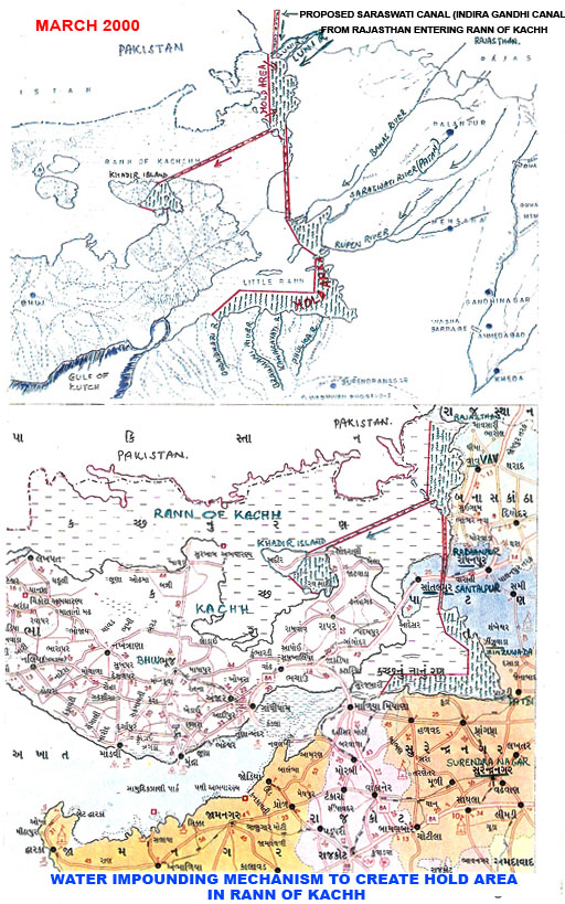 Map No. 4 along the coast of N. Gujarat, so as to create a longish North – South reservoir abutting N. Gujarat coast line. The management of this reservoir so created envisages the following:
(a) This North South Hold Area should be designed as to impound and hold, not only the canal water that flow-in through Rajasthan, but also the monsoon flow, alongwith the land run-off from the catchment areas of Luni, Banas, Saraswati (Sidhpur – Patan) and Rupen along the North Coast and Brahmani, Godadhari, Phoolzar etc. from N. Saurashtra coast. These area all ephemeral rivers and it should be noted that their monsoon run-off whatever, is totally wasted presently, always and invariably, as the discharge finally disappears into the Rann of Kachh, not a drop of which is utilized.
(b) From this Hold – Area, water can be carried through gravity, into mainland Kachh by a duct, a canal in preference to a pipe line. The earthen embarkments of such a canal should be wide enough to permit vehicular movement. This will facilitate direct access to Kachh from Tharad Segment of N. Gujarat, besides being conducive to faster Military Deployment of men and material.
(c) Such a Kachh destined canal will run almost super imposed on the prehistoric discharge course of River Luni, which once used to flow past Northern Coast of Kachh along Bela and Khadir Islands, go past Pachham for final discharge into the Arabian Sea. Therefore the natural gradient of the land set being East-West, the flow will be by gravity, not requiring any lift.
(d) During every monsoon of any intensity, the Rann sustains anywhere between six inches to five feet of monsoon water, the deepest accumulation being along the Patadi-Zinzuwada-Suigam Coast. And that is the coast-line along which the meager monsoon flow, whatever volume, of Luni, Banas, Saraswati, Rupen etc. accumulates. Thus, the entire North-South strip of North Gujarat coast suits well for being a Hold Area.
(e) The suggested reservoir should be used a launching pad for soil desalination through progressive reclamation concept, as has been effectively demonstrated by Israel. The concept envisages reclamation of soil by advancing one km. to three kms. every year depending on availability of water. It recognizes that infusion of water is the only effective anti-dote to salinity and to all the problems flowing from salinity.
(f) Pending the arrival of the proposed Satlej – Yamuna waters into N. Gujarat, the presently operational Narmada Canal can be used (or is it already being used?) to induct sufficient quantity of Narmada waters into Banas, saraswati and Rupen, though it can be put to productive use only is these waters are impounded and released progressively for specific application. However, presently such a Hold-Area as has been proposed herein does not exist to impound and hold the discharge.
(g) If and when implemented, the Satlej – Yamuna combine can be brought right at the threshold of Sabarmati in Gujarat. Thereafter or even before, the Damanganga (South Gujarat, near Vapi town) can be easily siphoned off into Sabarmati. If and when completed, it would form a Himalaya to South Gujarat arc, a kind of water grid that will bring immense joy and happiness to the people of Uttaranchal, Punjab, Haryana, Rajasthan and Gujarat including Kachh. It will connect the Himalayan waters, through Yamuna and satlej with such ephemeral rivers as Luni, Banas, Saraswati (Patan – Sidhpur), Rupen, Sabarmati in N. Gujarat, and Mahi, Narmadam, Tapi and Damanganga in Central and South Gujarat. This can form the largest and most extensive water grid encompassing some 200,000 sq. kms. In a single sweep. Collectively, it can irrigate an area that would be easily the largest in the world.
(h) Reverting to the Hold-Area as described in (a) hereinabove, I have come across a report that the Govt. of Gujarati is planning to create the largest man-made freshwater lake (in Asia), in the Rann of Kachh by bridging N. Saurashtra and S. Kachh at Surajbari, which is presently a corridor connection the two provinces. If true, the following are the ominus minus points.
- The Rann of Kachh is home to the world’s only concentration of Ghudkhar, a rare species exclusive to Gujarat. The proposed lake would submerge the present habitat of Ghudkhar. However, if the Hold-Area as suggested by me herein is created, it will not disturb the Ghudkhar at all.
- Saurashtra and Kachh collectively are the largest producers of marine based Common Saltt in the world or probably next only to Utah State of the USA. The little Rann of Kachh hosts vast area of Agar (Salt Pans) which will get submerged in the proposed scheme. If however, the Hold-Area that I have suggested is opted for, the Agars and Agarias (salt manufacturers) will be left undisturbed.
- The little Ran of Kachh hots the world’s second largest solid flat expanse after Utah in the USA, capable of hosting such martial sports as horse riding, horse mounted polo and above all, the wind –sailing which no other State of India can offer. All this flat land will be submerged in the said proposal. However, the Hold-Area as suggested by me will leave all such flat land untouched.
- Rather than the “Largest Man made Lake” label, I would prefer the “Most Purposeful Manmade Lake” label. The proposed largest lake would inundate a vast land area that could otherwise be converted into agriculturally productive area in course of time by progressive reclamation method (as stated in ‘c’ above) through infusion of fresh water from the Hold-Area (which will hold the flowing waters of Narmada Canal and monsoon run-offf of Luni, Banas, Sarawati (Sidhpur), Rupen Brahmani, Phuljar etc).
11. WE MUST ENTERTAIN A MUCH WIDER VISION TO EVOLVE A COMPREHENSIVE BLUE PRINT TO ADDRESS A WIDE SPECTRUM OF ENDEMIC PROBLEMS.
As we are planning to interlink river basins in the Himalayan, Central and Peninsular India, we must certainly entertain a much wider perspective to cover the following parameters in order to evolve an all –encompassing blue print at all – India level.
- Enlarging the acreage under irrigation which will automatically enhance the moisture retention capacity of soil.
- General de-desertification and prevention of onward march of desert.
- Establishment of Re-charge mechanism to prevent depletion of water levels through activation of dead or dormant aquifers.
- Desalinization of soil and water.
- Progressive reclamation of land for agricultural use from year to year as has been amply demonstrated by Libya and Israel.
- Prevention of migration of communities and cattle during the recurring visits of conditions of drought and famine which in some areas has become endemic eg Rajasthan, Kachh, Marathwada, Rayalsema, Kalahandi etc.
- Creating conditions for complementary re-charge of Wells, Talaos, Baolis, other waterbodies and sub-soil aquifers falling on the way of extension canal network. This, in turn, will obviate the need for excessive withdrawal of ground water which otherwise would send water tables sinking beyond redemption.
- Utilize paleo-channels of lost rivers, and/or dry channels of ephemeral rivers so as to revive such rivers and to activate the aquifers underneath.
- An overall rejuvenation of the land and the people inhabiting it through the ushering in of a water-based, water-propelled and water-sustained economy.
- Unless irrevocably needed, water flow through pumping mechanism must be shunned. The emphasis should be on a blue print that incorporates flow by gravity.
12. AT PRESENT RATE OF WITHDRAWALS WE WILL EXHAUST SUBTERRANEAN WATER MUCH AHEAD OF OIL.
India was once the largest repository of sub oil water (It, perhaps, still is) in the world. However, through indiscreet mining and exploitation of sub soil water resources, we have succeeded in virtually exhausting these stocks almost beyond redemption. We have hit the rock bottom, the fossil water pool, which surely is the last frontier that we can attempt to cross only at our own peril, at the risk of our future.
India is also endowed with vast deposits of oil, both Rajasthan and Gujarat included. As we all know, oil deposits certainly have a cut off date, a dead-end. What we do not know perhaps, is the fact that India has more wealth in Water than the Gulf Countries have in OIL. Whereas, oil can not be regenerated or recharged, the element of water readily lends itself to any recharge process. We have, however, defaulted on the recharge front and unwittingly run into a ‘beyond-salvation’ situation, almost. Therefore, if we do not stop indiscriminate exploitation of sub-soil water now, then, I am afraid, we do not have a TOMORROW. Under the circumstances, we run the risk of exhausting the underground water resources much ahead of the mandatory exhaustion of oil deposits.
13. RECHARGE CONCEPT DOES NOT EXIST IN OUR THINKING AND PLANNING. WE MUST ESTABLISH RECHARGE MECHANISM AT VILLAGE LEVEL. GUJARAT CHECK-DAM EXPERIENCE IS WORTHY OF EMULATION.
Post – Independence, India has taken up many Hydel and Irrigation projects, big and medium. Huge investments have been made in various River Valley Development Projects. The whole emphasis has been on constructing storages (which of course, no one would grudge), but never on establishing, a permanent Recharge Mechanism, simply because the concept never really existed in our collective thinking. During the decades that followed the Independence, we have succeeded in squeezing the Mother Earth dry, drawing more water, and more water, and yet more water from her womb and not yet stopped. As though the earth is an inexhaustible bottomless pit to draw from. As though the earth is an Akshai Paatra (an inexhaustible water bowl). It is outrageous that a nation and a people who pride themselves as recipients of the legacy and wisdom of the Vedas that describe water as “Jal hi jivanam” (water is life), have jettisoned that wisdom in utter disregard of its irrevocable message.
Having looted multi billions /trillions of gallons of water from the womb of Earth during the post – independence period by embracing the tube-well culture, it is high time we return it to where it belongs. We must mount a large scale, all-embracing Recharge Effort so as to revive the abandoned wells, tanks and water-bodies, small or big. In this direction, Gujarat’s example is worthy of emulation. Gujarat has already constructed more than, 1, 50,000 check dams on its ephemeral rivulets across the dry regions of Saurashtra, Kachh and N. Gujarat. Today, the perpetually dry Sabarmati and about three more rivers are flowing through recharge from the Narmada Canal. More than 100 dry village tanks (Talao) have been revived by connecting them with the Narmada feeders. As a result, in some of the dry regions, the water table has risen by about 200’, where earlier is stood depleted to a depth of anywhere between 500’ to 1200’. This is all the more remarkable at village level. And they have not stopped at that as the target is to add another one lakh fifty thousand Check Dams in the next two years.
Why can not this success be repeated in other States? Why do we necessarily have to depend on costly technologies which have yet to prove to be cost-effective, and in the planning and implementation of which the people are conspicuous by their absence?
14. RECHARGE BAOLIS, WELLS, TAALAOS (WATER TANKS) ON THE WAY ON VILLAGE OUTSKIRTS THROUGH MAN MADE CANALS.
Since time immemorial, Indian villages have devised their own water supply mechanism of which the Baolis, Wells, Taalavs etc. have been inalienable ingredients. They depended for their supplies and replenishments, primarily on the rains during the monsoons and on the aquifers thereafter. The rivers of course were potent conduits of water to those villages situated on the banks. Whereas the rains, rivers and aquifers were water suppliers, the Baolis, Wells and Talaos (Water Tanks) served as water containers and the forests, vegetation, slushy soil and impervious rocks acted as water retainers. In contemporary times, all these self evolving cyclic systems have collapsed due to a near total absence of comprehensive soil, water and forest management culture.
Any canal network, therefore, should be so designed as to go past the village outskirts whereby a small duct can be put into the village Talao or Baolis. This system will instantly revive the Talaos and activate the long dried up aquifers. Besides, canals which are left unlined and unpaved tend to cause seepages which is a welcome phenomenon as it provides artificial recharge mechanism all along the course of the canal. In our anxiety to seal all pockets of seepages, the planners have lined (to prevent transit loss of water) many canals with cement veneers. In doing this, the planners may have a valid reason, but it divests the dry tract of land in transit, of an opportunity to receive artificial recharge, which would have otherwise percolated to lower start and thus activated the aquifers. Little do we realize that in the scheme of Nature, no river course is ever lined with any cementing bond to prevent percolation. Rather, it is the explicit purpose of Nature to allow unhindered percolation of water to lower levels of the crust to make and keep the soil damp. On this dampness of soil survive the algae, vegetation and all forms of life.
15. SUCH CANALS SHOULD PREFERABLY RUN ON THE ABANDONED CHANELS OF LOST RIVERS.
For example, Rajasthan abounds in the proliferation of palaeo – channels abandoned by migrating rivers. The great are between Luni in South and the Ghaggar in North, the lost Drishadwati sandwiched between them, shows a cobweb of shifting channels. From Pachpadra (On Luni) in the South to Suratgarh (on Ghaggar) in north, the terrain is replete with paleo – channels vacated by Parent Rivers, whatever the cause. To be more specific, the Suratgarh – Lukransar – Bikaner – Kolayat – Kishengarh – Ghantiyali Sector or Ghotaru – Ramgarh – Lodarva – Jaisalmer – Gadra – Pokran – Shiv – Badmer Sector or Churu – Didwana – Metra – Jodhpur – Panchpadra Sector, all show a labyrinth in the Thar desert of criss – crossing channels, depressions and residues /leftovers of the remote past. These paleo – channels should come handy to the designers of any future network of canals which would go a long way in rejuvenating the soil and ground water source through activation of countless aquifers.
Further, wherever possible, the canals should be emptied into existing channels of functional rivers, eg. Luni and Banas, both originating from the Aravalli chain. The left Bank Yamuna Canal system, the many ramification (tail end) of which terminate at near Jamalpur (Sunder Branch) Bhiwani (Bhiwani Branch), and Jhajar (Jhajar Branch), readily lends itself to the prospect of discharging its contents into the dry and seasonal channel of Luni, which is still a functional river, even if ephemeral. This is clearly illustrated vide Map No. 2 and Map No.3. Similarly, there are innumerable channels, dry and abandoned, of rivers that are ephemeral and/or or have changed their course, in central and peninsular India (eg. Vidarbha, Marathawala, Rayalseema etc.) Wherein such channels can be revived rejuvenated and aquifers activated.
16. LOOP (CONTOUR) CANAL SYSTEM MOST SUITED FOR CONNECTING MAIN STREAMS IN THE SAME BASIN. IT EMBODIES THE GARLAND CANAL CONCEPT.
For example, both the Western Yamuna Canal (WYC) and Eastern Yamuna Canal (EYC) take off at Tajewala (Haryana ) from the mainstream Yamuna and rejoin the river downstream of Delhi (Map No. 2). The WYC also ramifies unto Hansi Branch, Sundar Branch, Bhiwani Branch, Rohtak Branch, Jhajjar Branch etc. serving the Haryana landscape in a wide arc. All these canal terminal points can be joined to form an arc so as to maintain an even-flow pattern in order to draw supplies from any of these terminal points (Map No.2). If any one of these terminal points was extended and put into the Luni at somewhere near Panchpadra in Rajasthan (Map No.3), that would instantaneously revive the ephemeral Luni and usher in the Himalayan water into Rann of Kachh through Rajasthan by gravity ( I would recall here that in the monsoon of 2002, an excess discharge of about 200000 cusecs was released from Tajewal reservoir on the Yamuna and frittered away in the desert of Rajasthan. Had there been a canal extension from any of these terminal points in place, this volume of water could have been carried into Kachh through Rajasthan instead of being wasted).
The advantage that could be derived from loop (contour) canalling system is as under:
- It helps siphon off excessive flood water from the main stream into its parallel – flowing sister stream, wherever connected, going along with gravity.
- Such loop – connecting canals, whatever quantity they draw from the main stream, put it back into the latter some hundred kms downstream after serving the adjacent areas through which they meander their way.
- It beings wide land areas under irrigation through feeder network.
- It helps recharge depleted water table.
- Moreover, it flows back into the mainstream thereby replenishing the mainstream with its residual supply.
- It not only does not interfere with the function of the subterranean aquifer’s network of contribution /distribution, it also helps replenish the latter through silent percolation.
- Such a network of loop (contoured) canals which act at once as distributaries and contributories will be less prone to the problem of siltation than the principal rivers they take off from and remerge into.
It is everybody’s knowledge that Yamuna, Ganga, Gomit, Ghagra, Gandak and scores of rivers flow down the Himalayan slopes, run almost parallel to each other in the same direction until they all finally merge into the mainstream Ganga. If these arteries are interlinked through a network of canals, flowing out of and into each other in descending direction (i.e. neither across nor in ascending direction, unlike the envisaged Ganga – Brahmaputra linkage or Sharda – Yamuna linkage as proposed in the ILR map – Map No.1) then the entire Ganga Basin will be the beneficiary of accruals as listed from (a) to (g) in the foregoing. Similarly, the contributories flowing into the Yamuna – Ganga Basin from the Southern Flank, viz. the Chambal, Sindh, Betwa, Kenn, Sonn etc. too should be interlinked through loop – controured canals for final discharge into Ganga Basin so as to give India’s largest water basin a compact, comprehensive and sustainable system that can be taken up as a case study which, if found remunerative in term of flood-control, widened base of irrigated cultivation, eco-sustenance, ground water recharge etc. then the experiment can be repeated in any other selected river basin in peninsular India as a follow-up.
17. STORE THE RIVERS UPSTREAM, IN PREFERENCE TO DOWN STREAM, FOR BETTER WATER USAGE AND MANAGEMENT. MORE STORAGE SHOULD BE POSITIONED ON THE CONTRIBUTORIES RATHER THAN ON PRINCIPAL RIVERS.
Farakka, situated almost at the ending end of Ganga, readily lends itself to silt-deposits that flow in from al directions, primarily due to its situation downstream that makes it a huge storehouse of accumulated silt.
- Such dams tend to fill up with silt deposits much ahead of anticipated time - frame, as the longer the water course the greater is the volume of silt-floating along with it.
- As opposed to down stream dams, upstream dams command a larger sweep and reach for canal distributaries and feeders to penetrate far and wide in the countryside.
- Besides, such storage upstream cause fewer displacement of villages, cause lesser submersion of arable land and forest cover.
- The only retarding factor of upstream dams being smaller catchment area.
- Big downstream dams, wherever and if necessary, should stand supported by a series of upstream dams. For example, the Sardar Sarovar Dam on Narmada stands supported and replenished by about 30 storages upstreams, both on the main river and its contributories as well.
In this context, as a matter of an example of proven merits, I am attaching herewith part of a 1939 map
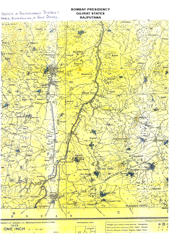 (Map No.5) of what was then Bombay Presidency (Panch Mahal Districts – Gujarat), showing River Machhan and surrounding areas. In this case, the principal river is Mahi (of Aravalli origin) which is not in the map. The main contributory of Mahi on its Southern flank is River Anas which too is not in the map. River Machhan as shown in the map is a major contributory to river Anas which ultimately falls into River Mahim.
In the map, we see countless number of storages which are positioned on small rivulets, many of them mere nullahs. These innumerable rivulets flow into their mother stream Machhan which DOES NOT have a single storage built across it. These storages, besides being source of supply to countless villages and towns also replenish subterranean aquifers and recharge depleted water tables. They also withhold silt deposits before charging their overflow, through feeder Nullahs, into River Machhan which carries it into River Anas and onwards into the principal River Mahi, thereby minimizing land erosion!
Moreover, the small black round dots and squares seen in the map in hundreds are wells and tanks that are placed strategically in every field, every village and every back yard. Hundreds of them have been placed on the edge of countless Nullahs that meander their way into the river, recharging the wells every monsoon. In having evolved this simple self-sustaining mechanism of use, re-use and recharge, the rustic peasant of India has demonstrated that more than high, intricate technology of wasteful expenditure, it is the down-to-earth common sense approach that should form the basis of community survival and sustenance.
The foregoing also supports the points as listed from 17 (a) to (e) hereinabove.
18. WE HAVE ONLY 20 YEARS LEFT TO REJUVENATE OUR LAND
According to a. U.N. survey, vast areas in the world will almost exhaust their ground water repositories by the year 2025, the Sahara and Sub-Sahara regions in Africa, and North West India topping the list. Often, in various world fora, experts discuss at great length about the need of global water management. However, by the year 2025/30, there will be hardy any water left for us to manage.
We, individually and collectively (bureaucracy and the political leadership included) have failed to realize that there is no such infinite containers as “Akshai Paatra”. Such a container DOES NOT exist. It existed only in folklore or in the fantasy world of poets. Even the vaults of Sri Kuber (god of Wealth) is NOT ‘Akshai’, it can not remain ‘Akshai’ if not replenished. We have almost evacuated from the womb of Earth during the past 60 years, what Nature had given to us during the previous millions of years. Unless we urgently evolve and set-up recharge mechanism to replenish the accumulated loss, disaster of unimaginable magnitude will soon overtake us.
What measures we should undertake to effectively recharge the land?
- Shun the Tubewell Culture. We must understand, now and forever, that mechanical withdrawal of water through the Tubes drilled in any one big farmland, leads to the emptying of water sources in and around ten other small holdings. Divesting others of their rightful share of water should be viewed as criminal offence.
- Let there by a concept change over, from mechanical pump based irrigation to drip irrigation. We do not need water-clogged soil, we need only damp soil for seed germination.
- Encourage village – level people – led small check – dam culture. This also includes mini Khet – Talaos, i.e. small water bodies (small ponds) created in a corner of every farm holding. This will help rain water collected during the monsoon, percolate to lower levels and thereby retain soil dampness.
- Every irrigation canal should be designed to pass through village periphery, a feeder from which should fall into village Taalaos (Tanks – Ponds – Waterbodies – Wells etc). This will lead to all round land rejuvenation.
- Revive the dry and/or abandoned beds/ channels of ephemeral river, which are found a plenty all over India. This can be very well be done by charging man-made canal waters into the former. Gujarat has done this by charging Narmada Canal water into the dry bed of Sabarmati in Ahmedabad. Two N. Gujarat rivers, Rupen and Sidhapur Saraswati will soon be charged.
India has the most wide-spread irrigation canal network in the world. How many of these canals have been utilized to charge dry /abandoned channels of lost /ephemeral rivers anywhere in India? Little do we realize that by reviving the rivers, we will be reviving depleted underground water tables, will be reviving the algae and thereby vegetation, will be reviving the fertility of soil.
19.MOTHER EARTH – THE FINEST SIEVING APPRATUS OF ALL AND EVER.
There is no apparatus, no water management agency, no instruments of governance, no human effort that is better at attracting, sieving, filtering, retaining, storing and distributing, (through its countless conduits in the form of aquifers) the element of water than our own Mother Earth. Over the trillions of years of its existence, it has worked in tandom with rains and forests. It is these very vital, life – endowing elements that we have utterly ignored while planning. It is in recognition of these finer qualities of Earth that I have suggested measures as in points (2) and (3) in the foregoing.
Our planners while designing any scheme, do anticipate (and, surely they have a point) the loss of water through seepage. However, in the long run, we should perceive it as a gain rather than loss, as the quantity of water that has percolated to lower levels through out the course of the canal, do actually build up a repository of water under the crust. It also feeds and continues feeding the aquifers which, on their part, keep the soil alive and throbbing. And that is exactly what rain water does, keeping the soil damp and moisture-laden, from where life germinates and blossoms.
20. THE INDIAN FARMER IS A NATURAL SCIENTIST
We, the University bred educated class have often dismissed that non-descript holder of small piece of land, the Kisaan, as an uncompromising traditionalist, rooted in the obscurities of the past. However, what we have failed to recognize is his innate ability to correctly interpret the behavioral pattern of elements of nature. He is a born scientist. For many millennia he has been forecasting the advance or otherwise of the monsoon in his own strange – sounding ways. He is a keen observer of the direction of the wind, the movement of a particular species of bird, the blossoming of flowers. Perceiving and interpreting the configuration and interplay of all these contributory factors, he sets his compass in his mind frame and goes about his business in a thoroughly scientific way. He knows his piece of land well, he understands the signals of elements of nature well, he communicates with his pair of bullocks with astounding clarity. He is the soul of India and an inalienable component of our larger society who has sustained India’s agriculture through the ages. He does not need any education from us in the nuances of agriculture. He needs from our administrative establishment, supportive ingradients to enhance his efforts. And that indispensable ingredient is WATER. Therefore, it is the responsibility of the State to provide our farmers with water through judiceous planning of irrigation system/ canal network to enable our farmers to work the miracle.
21. WHOSE WATER IT IS ANYWAY? WHO OWNS WATER? THE STATE? THE MULTINATIONALS? WATER, THE ELEMENT OF NATURE IS NOBODY’S PROPERTY. IT IS AN ENDOWMENT OF NATURE. THEREFORE, LET PEOPLE BE THE PARTICIPANTS AS TRUE INHERITORS OF NATURE’S LEGACY.
In the realm of soil and water management, we now find that the people are often victims rather than beneficiaries of the State Policy. This is primarily because of our flawed concept of ownership of natural resources. All endowments of nature should be perceived by us as being of collective legacy to be held in Trust and employed for common good of all, (Sarva Bhoota Hiteshu). Such perception will automatically lead us to the reorganization of the people, not the State, as the inheritor and holder of the instrument of Nature’s endowment.
More than fifty five years after independence, our sisters and daughters are still made to walk beyond 2 kms to fetch half a bucket – full of water. This reprehensible fact should have shamed us all, collectively, and more so, the bureaucracy and the political leadership as well who are entrusted with the task of evolving a national soil and water management policy. In Rajasthan, Kachh, Rayalseema, Marathwada, Kalahandi etc. the people are perpetually condemned to a life of drudgery, as though sentenced to life. It is because the State has failed to involve the people at different levels of planning, implementation and management of soil and water, of which the people should have been perceived by the State as the rightful beneficiaries. And it is due to the misplaced notions of ownership of natural resources that the various State of the Indian Union are daggers drawn against each other on the issue of sharing of waters. It is of little significance that water is State subject and Oil – Gas are Federal subjects. What should have been of great consequence is the much-awaited recognition that Water, Oil, Gas et al are Nation’s assets meant to be utilized for the benefit of the people as being the subjects of the Indian union. If this were the spirit in which we had worked involving the people at all levels of planning, implementation and management of soil and water, as being the true inheritors of Nature’s Endowment, then surely by now we would have banished the specter of famine and want.
I would therefore suggest in all humility that at the very planning stage, do invite the people through NGOs to give the people not only the sense of participation but also of partnership. The concept of global Water Partnership is surely a nice appellation, but bereft of the involvement of our own concerned people, it hardly has any meaning.
22. THE BEST RAINS IN ISRAEL IS NO BETTER THAN THE WORST-FAILED MONSOON IN INDIA.
Again, the question is that of management of whatever quantity of water we receive from nature, year after year. We are quick to blame the monsoon whenever the economy shows a decline. In fact, it is politician, not the farmer, who has failed. It is the planners not the people who have failed. Let us understand the basics. If India’s huge stock of ground water stands depleted today at an abysmally low level, if India’s primeval forest cover is fast disappearing into oblivion, it is not the monsoon but the flawed planning and management of soil, water and forests, that has failed us. People do not fail the State. The state often fails the people. History bears testimony to it.
Israel, otherwise a non-descript chunk of territory, has worked miracles with what meagre water asset it possesses. It knows it can not afford the prodigal tube-well water evacuating culture. It has very wisely embraced the drip – irrigation system which effectively keeps the soil damp which is all that is needed for vegetation to germinate. In contrast, India has huge water assets and some of the most fertile soil in the world. It is endowed with a full-fledge monsoon season that is the envy of the world. Israel has learnt to manage and benefit from what it had. India has wasted and frittered away it’s a natural assets and not yet learnt. Therefore, it is high time we opt for drip irrigation in preference to the wasteful, mechanical pump oriented, irrigation culture.
23. LET US UNDERSTAND THE EFFICIENCY OF HUMAN HEART. IT CONSUMES MUCH LESS ENERGY THAN IT GENERATES.
Human heart is the most efficient pumping mechanism of species ever installed by nature. As we all know, its primary function is to circulate blood in the body, so vital for human existence. However, little do we know that it consumes only 5% for its own metabolic activism, pushing another 95% through the body to keep the latter’s varied systems ever functional. If I were to push this analogy to cover hydel power sector, it would be a pertinent question to know how much electric power all the pumping mechanisms would need to hoist the Northern rivers’ water some 2000 feet upward which is the level difference between the two regions, i.e. North India and Peninsular India? Surely, to propel the water from suction end (i.e. from Rivers of North India) to delivery end (i.e. to Plateau and Rivers of Central and Peninsular india), it has to be lifted to a height of 2000 feet, being the level difference between the said two regions. How much power would be needed for this effort, in terms of Mega Watts? And how much power could be generated to feed such a stupendous exercise and at what cost? If the North – South inter basin transfer would consume more energy than it is envisaged to generate, then we had better learn out lessons from our own heart. This is where the Cost /benefit ratio comes into play.
24. AND LASTLY, THE SEA NEEDS ITS SHARE OF FRESH WATER AS DOES THE LAND.
Why only the land, the Oceans too need to be charged with supply of fresh water or else neither the Oceans nor marine life can survive, as had happened with the Dead Sea. In fact, no nation on earth contributes more fresh water to the seas than India, except perhaps, Brazil. The Amazon contributes so much to the sea that the estuary discharge of fresh water pushes the sea back for 60 kms. In India, the Ganga – Brahmaputra combine, the delta being some 250 kms wide, causes quite a fresh water impact on the sea in the Bay of Bengal as does the Shindhu in the Arabian Sea.
Life, involving all life-forms, is essentially a cyclic phenomenon, as has been long espoused by the Vedas, water being the nucleus element. As is clearly pronounced by the Vedas, the Sea lets some portion of water to evaporate from its repository; which forms into water bearing clouds which rain down on Earth; which leads to germination of seeds sprouting into grains and vegetation; which becomes food and nourishment for creatures of all species; which fertilizes and potentiates life; which thereupon evolves a pre-ordained life cycle; and then the residue of water flows back into the sea. (Taitreya Brahmna quoted in satyartha Prakash by Swami Dayananda Saraswati).
It is this residual water, expressly needed for recharging the Oceans, that man must lean to let back into the oceans as the latter’s legitimate share or else the cycle of life, as foretold by the collective wisdom of India’s sages, will be thrown into disarray to the detriment of mankind.
Before I come to a close, I would like to asset that the foregoing is not a stand in favour of THIS and/or against THAT. It is rather a dispassisionate study and a larger, anticipatory view of our national future on the water front as it unfolds itself in course of time. Let it dawn on us, the sooner the better, that the words “Surplus” and/or ‘Deficit” do not exist in Nature’s lexicon. Rather “Balance” and “Equity” are the words man must lean to read. There is no such thing as “Surplus Supply” or “Deficient supply” of Nature’s ingredients. We must lean to read them as “Balanced Supply” and “Equitous Supply”. Do we know that an elephant eats no more than an ant needs to eat? Do we know that an elephant environments? That is the message Nature sends us, in an eloquent silence. In essence, the Nature is not an economy of waste but of purposeful benevolence. Learning from our ancient scriptures, we must plan to restore “Balance” for the purpose of “Equitous” distribution for the benefit of the people and the eco-system alike.
Water is the nucleus of life cycle, the world exists by water. Want of water causes destruction of life. Therefore, never deny water to the famined as water sustains life.
Let the wisdom of the Vedas rain on us all.
THE CONCEPT (AND ITS COROLLARIES) DOCUMENT
1. THE CONCEPT:
(a) Forget the Himalayas as being the infinite source of water. The Glaciers are retreating. DO NOT evolve any strategic planning on the conceptual assumption of the Himalayas as being the infinite storehouse of water.
(b) Forget the ‘Surplus Water availability” concept. Think of managing whatever the Nature has given us, whether a drop or an ocean. Those who can not manage a drop are never well placed to manage an ocean either.
(c) Develop the concept management of available resources of soil, water and forests. Benefits of every description and accruals of cash and kind will automatically flow therefrom.
2. THE AIM:
(a) To prevent the migration of people and livestock n search of food and fodder, a recurring yearly phenomenon in many drought prone, famine stricken districts of India.
(b) To arrest the March of desert and salinity through infusion of water.
(c) To enhance the growth of agriculture, forests and common vegetation by bringing larger acreage under irrigation.
(d) To protect and preserve eco-system.
(e) To make drinking/potable water available 24 x 365.
(f) To engineer rural rejuvenation through growth of cattle / livestock based agro-economy that triggers socio-eco-cultural transformation at village community level.
(g) To rejuvenate the productivity and fertility of land/soil by reviving ancient Taalavs, Tanks, Baolis and water bodies of every description through fresh water infusion by establishing recharge mechanism at village level.
(h) To revive abandoned palaeo channels of lost or ephemeral rivers by using them as linkage canals /conduits.
(i) To create and encourage water born transport and navigation (as on Ganga) on arterial canals and back-water lagoons (as in Kerala)
3. THE URGENCY AND PRIORITIES:
(a) Establish Recharge Mechanism at Village level or perish.
(b) Undertake /encourage small scale Check Dam construction at District level on all dry /ephemeral rivers/nullahs to arrest depleting levels of ground water tables and to bring up levels.
(c) Evolve drip –irrigation culture in an urgent switch over from mechanical pumping devices in fiends and villages.
(d) Ban tubewell/borewell led water withdrawals, the principal cause of depletion of ground water sources.
4. BENEFICIARIES:
(a) People in general.
(b) Woman in particular (in both urban and rural area, women are perceived are treated as the beast of burden.)
(c) Agriculture in preference to industry.
(d) Food grains farming in preference to Sugarcane Specific farming. (The latter consumes much larger volume of water to the detriment of other crops).
(e) The villages in preference to cities. (The cities are eating up the earth’s natural resources.)
5. THE THRUST AND DIRECTION:
(a) Go for inter – basin transfers within and between parallel river systems in preference to inter region transfers (from North Region to South Region.)
(b) Set-up multiple smaller storages on contributories upstream in preference to single, huge, unwieldy ones on principal rivers downstream.
(c) Wherever possible use existing dry /abandoned river channels as water conduits /linkage for inter basin transfer.